A more Accurate Map of the Whole World
We have already seen the positions of the Continents in the previous page. Now we look at a more accurate map which resembles the shapes of the actual continents
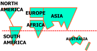
Let us look at the continents once more. See their shapes.
Hey, wait a bit... what is that red dotted line through the middle of the map. Is it not the Equator.
Yes, it IS the EQUATOR, and this line goes through some of the hottest and wettest places on this entire globe. Because when it is hot, the water evaporates creating a lot of rain. And all this rain makes for lot of trees and the result: Forests
- North America: looks like a Cup
- South America looks like a Glass !!
- Europe is shown here as a box but it is actually more complicated: we will take it up later. And we WILL simplify. That is what this site is all about. For now make do with a box ;)
- Africa is like a rectangle over a triangle
- Asia again is more complex than it looks here. Wait for a while for more simplification...
- Australia looks like an Apple. The thin rectangle beside it is New Zealand. And the two together are called Australasia
- Antarcticaor the South Pole is right below every other land mass (not shown on this page)
Hey, wait a bit... what is that red dotted line through the middle of the map. Is it not the Equator.
Yes, it IS the EQUATOR, and this line goes through some of the hottest and wettest places on this entire globe. Because when it is hot, the water evaporates creating a lot of rain. And all this rain makes for lot of trees and the result: Forests
